


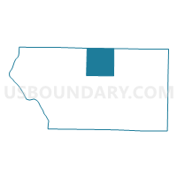
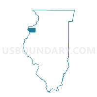
PERRYTON Voting District, Mercer County, Illinois
About
Outline

Summary
| Unique Area Identifier | 573577 |
| Name | PERRYTON Voting District |
| County | Mercer County |
| State | Illinois |
| Area (square miles) | 36.37 |
| Land Area (square miles) | 36.35 |
| Water Area (square miles) | 0.02 |
| % of Land Area | 99.96 |
| % of Water Area | 0.04 |
| Latitude of the Internal Point | 41.28785580 |
| Longtitude of the Internal Point | -90.71849460 |
Maps

Graphs
Select a template below for downloading or customizing gragh for PERRYTON Voting District, Mercer County, Illinois


Neighbors
Neighoring Voting District (by Name) Neighboring Voting District on the Map
- BOWLING 1 Voting District, Rock Island County, IL
- BUFFALO PRAIRIE Voting District, Rock Island County, IL
- DUNCAN Voting District, Mercer County, IL
- EDGINGTON 2 Voting District, Rock Island County, IL
- MERCER 6 Voting District, Mercer County, IL
- MILLERSBURG Voting District, Mercer County, IL
- PREEMPTION 1 Voting District, Mercer County, IL
- PREEMPTION 2 Voting District, Mercer County, IL
Top 10 Neighboring County Subdivision (by Population) Neighboring County Subdivision on the Map
- Mercer township, Mercer County, IL (4,071)
- Bowling township, Rock Island County, IL (3,414)
- Preemption township, Mercer County, IL (1,783)
- Edgington township, Rock Island County, IL (1,508)
- Buffalo Prairie township, Rock Island County, IL (824)
- Millersburg township, Mercer County, IL (755)
- Perryton township, Mercer County, IL (474)
- Duncan township, Mercer County, IL (272)
Top 10 Neighboring Place (by Population) Neighboring Place on the Map
Top 10 Neighboring Unified School District (by Population) Neighboring Unified School District on the Map
- Mercer County School District 404, IL (8,787)
- Rockridge Community Unit School District 300, IL (7,392)
Top 10 Neighboring State Legislative District Lower Chamber (by Population) Neighboring State Legislative District Lower Chamber on the Map
Top 10 Neighboring State Legislative District Upper Chamber (by Population) Neighboring State Legislative District Upper Chamber on the Map
Top 10 Neighboring 111th Congressional District (by Population) Neighboring 111th Congressional District on the Map
Top 10 Neighboring Census Tract (by Population) Neighboring Census Tract on the Map
- Census Tract 401, Mercer County, IL (4,579)
- Census Tract 241.03, Rock Island County, IL (4,046)
- Census Tract 402, Mercer County, IL (3,754)